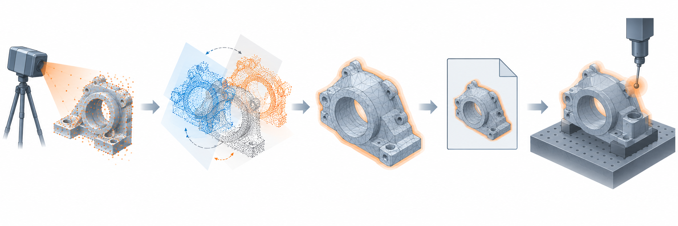
A scan handoff is more than a file containing many points. The recipient needs to know what was measured, how the datasets were aligned, how the representation was derived, and whether the remaining uncertainty is acceptable for the intended use.
Identify the payload
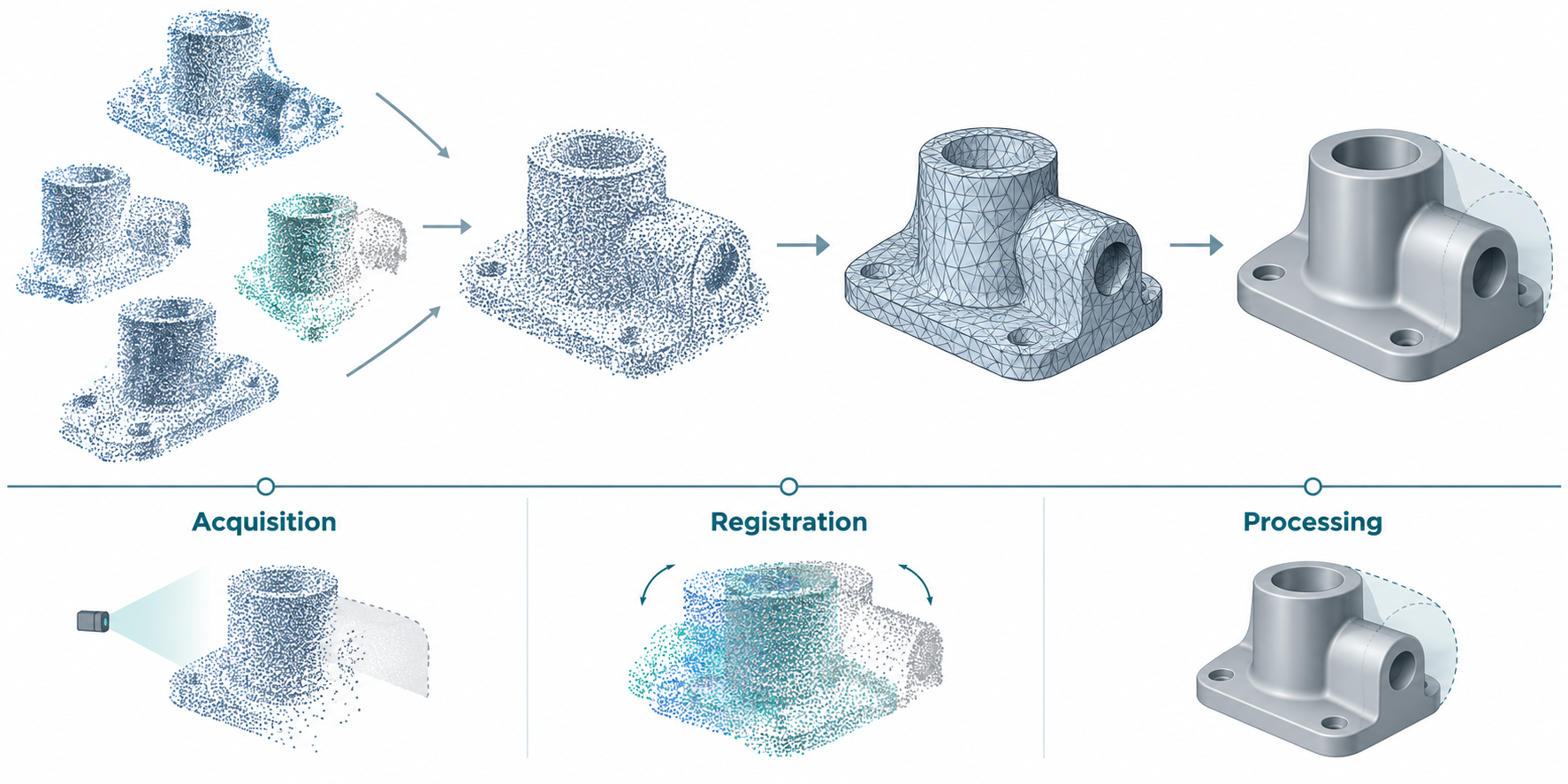
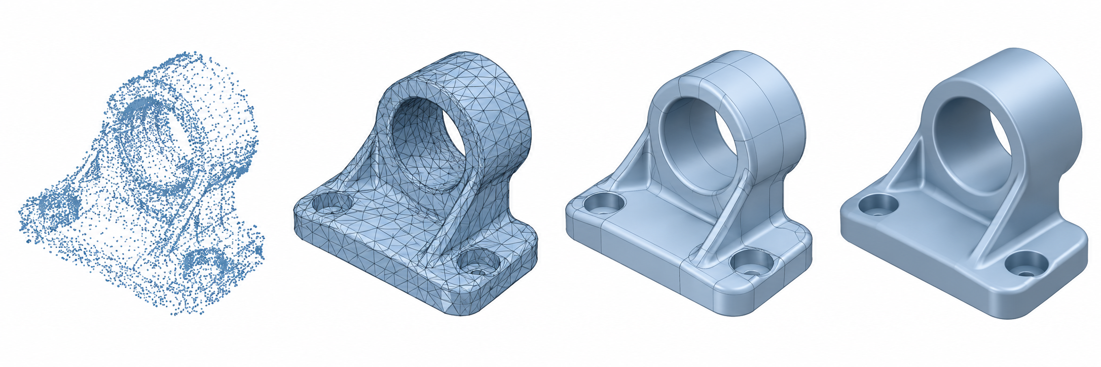
Do not use “scan model” as if it named one representation. A delivery may contain:
- a point cloud containing sampled coordinates;
- a triangulated mesh derived from points;
- fitted curves or surfaces derived from the scan;
- a solid or CAD model reconstructed from those surfaces;
- a hybrid package retaining the points alongside derived geometry.
Each step can introduce a different error or discard information. A point cloud does not become an exact CAD surface merely because it was meshed, and a reconstructed surface does not carry the original measurement uncertainty unless that relationship is documented.
When color is part of the required point-cloud payload, assess it separately from geometric coverage. A NIST study evaluated colored point clouds from two LiDAR-camera fusion systems and one stereo-camera setup using point spread, area coverage, and color difference against a test artifact. Those measures ranked the tested systems; they do not establish CAD-transfer fidelity or general scanner accuracy.
Separate the uncertainty budget
Consider these layers independently:
- Acquisition: scanner calibration, sensor limitations, viewing conditions, and the uncertainty of the measured points.
- Registration: transformations used to put multiple scans into a common coordinate system, plus residual alignment error.
- Representation: point spacing, filtering, hole filling, meshing, surface fitting, and simplification.
- Transfer: units, coordinates, file/profile version, and attribute or metadata preservation.
- Downstream use: the tolerance and operation that will decide whether the result is acceptable.
Higher point density does not automatically mean higher accuracy. A dense but poorly registered cloud can be less useful than a sparser cloud with a documented, appropriate uncertainty.
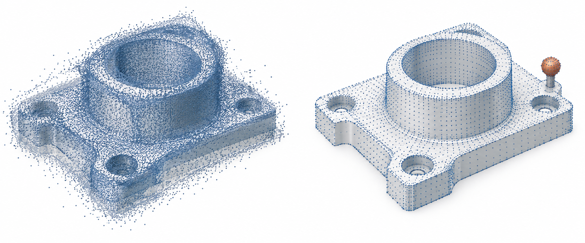
Depth resolution is also distinct from point spacing and accuracy. NIST defines it as the smallest depth change that produces a perceptible change in the measured indication. Its study estimates resolution from repeated flat-target captures and quantization under controlled conditions; target shape, sensor position, surface, lighting, and other conditions affect interpretation. That method does not establish scan-to-CAD accuracy, reconstruction error, or a downstream acceptance limit.
What the format evidence does and does not say
OGC describes LAS as an open format for lidar and other point-cloud records, commonly carrying X, Y, and Z point data. That is a payload and interoperability purpose statement; it is not a scan-to-CAD procedure or accuracy guarantee.
Version context matters. The ASPRS LAS release history lists LAS 1.4 Revision 16 and LAS 1.5 Revision 00 with changes affecting record formats, GPS-time handling, and CRS-related behavior. A handoff should state the LAS version and point data record format, then verify the fields in the actual producer and consumer rather than assuming support.
ReCap’s E57 export choices show why the selected mode belongs in that record. Its structured-point-cloud-only, no-edits option retains row, column, and return bounds plus line grouping, while the edited point-cloud-only option converts structured input to unstructured points. The cloud-plus-panorama option carries image representation alongside point data. These are documented ReCap output semantics, not a test of another E57 reader; inspect the received organization, units, transforms, and required imagery rather than assuming the source structure survived.
The USGS 2025 Rev. A lidar specification provides a bounded delivery-control example. It prefers consistent horizontal and vertical units, requires source and point-source identification to persist through processing and delivery, and calls for documented positional-accuracy verification. Those controls are for USGS lidar delivery. They should not be copied as mechanical reverse-engineering tolerances without establishing applicability.
Registration and uncertainty need context
NIST describes a method, in the ASTM E2919-22 static-pose context, for calculating orientation error and uncertainty from 3D point-cloud data. This supports recording orientation uncertainty as evidence rather than describing a cloud only by density. It does not establish a universal point accuracy threshold or a complete scan-to-CAD acceptance method.
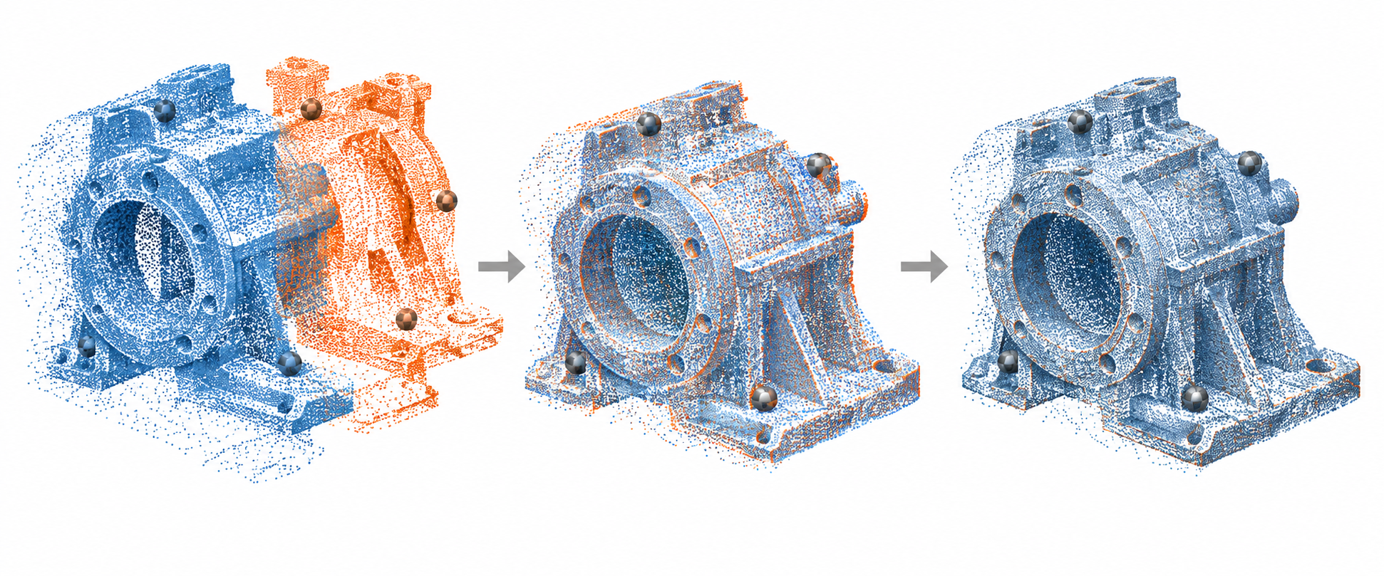
Fitting a known CAD model to a partial line-of-sight scan has a separate risk: self-occluded convex and concave surfaces can mislead ICP into an incorrect pose even when the starting alignment is useful. In NIST’s bounded experiment on socket-head screws, point clouds from a Zivid One+ Small sensor were manually segmented; a Faro Quantum S multi-view scan was also used for comparison. Using only CAD vertices visible from the initial pose reduced residual error by a factor of three to four in all but one tested case. The result depends on the tested screws, sensors, segmentation, and initial pose. A smaller residual alone did not always indicate the better physical alignment, so record visibility, segmentation, starting pose, and the comparison method instead of treating one residual threshold as proof of fit.
The full NIST IR 8499 method is deliberately bounded. It uses at least 200 point clouds of a non-symmetric artifact collected under statistically equivalent conditions, checks method-specific point-count, coordinate-extrema, and missing-point limits, and uses the 95th percentile of orientation deviations as the reported uncertainty. Its test result of 2.204 milliradians came from more than 250 segmented datasets of one artifact. Do not reuse those conditions or that value as a universal scanner, reconstruction, or CAD-acceptance threshold; the report also says its supplied software does not validate inputs and has not been shown compatible with every software version.
An OSAC 2025-N-0022 open-comment proposal gives another bounded example for terrestrial LiDAR capture. It distinguishes target-based registration using shared reference objects from targetless or cloud-to-cloud registration using overlapping geometry. It also relates scanner angular resolution to point spacing at a stated distance and recommends selecting point spacing and accuracy for intended use. Because the document is proposed and focused on forensic-scene capture, treat it as contextual guidance, not a finished universal CAD standard.
For coordinate reference systems, transformations, and spatial semantics, use the portal’s spatial-context guidance. This category records the geometry and uncertainty that affect shape interpretation; it does not define a universal coordinate system.
Build a useful handoff package
For a point-cloud or scan-derived delivery, include:
- payload type: points, mesh, fitted surfaces, reconstructed solid, or hybrid;
- format, version, point data record format, and required extensions;
- units, coordinate system, transformations, and a known-size reference;
- scanner and acquisition context where relevant;
- registration method, control objects or overlap basis, residuals, and orientation uncertainty;
- point spacing or mesh-density settings and any simplification or hole-filling step;
- measured or estimated accuracy and the method used to obtain it;
- source IDs or tile relationships needed to trace points back to acquisition;
- known holes, occlusions, outliers, reconstruction exclusions, and unsupported attributes;
- the downstream purpose and the acceptance check the recipient must perform.
Match the package to the purpose
| Downstream purpose | Ask first | Do not assume |
|---|---|---|
| Reverse engineering | Are the samples registered and dense enough for the feature and fitting method, and is derived-surface deviation measured? | A mesh is an exact replacement for the measured object |
| Visualization | Are the mesh attributes, scale, and visual quality adequate for the intended view? | Visual smoothness proves dimensional accuracy |
| Inspection or measurement | What uncertainty, reference frame, and comparison method govern acceptance? | Point count alone establishes measurement confidence |
| Fabrication or printing | Is the derived representation closed, oriented, scaled, and qualified for the actual process? | A valid file or repaired mesh is production approval |
The evidence available here does not establish universal scan-to-mesh, scan-to-surface, or mechanical-CAD handoff thresholds. If those criteria are material and not already defined, route the need to a domain owner or obtain task-specific evidence before promising an outcome.
Handoff checklist
Before sending, ask:
- Can the recipient identify exactly what was measured and what was reconstructed?
- Can they reproduce the unit and coordinate interpretation?
- Can they inspect registration and uncertainty rather than infer it from density?
- Can they distinguish raw points from derived mesh or surfaces?
- Can they compare the result against a purpose-specific acceptance rule?
If the answer to any of these is no, mark the limitation explicitly and avoid presenting the scan-derived geometry as more certain than the evidence supports.